A commuter’s survival guide to Houston traffic during the 2026 World Cup: Worst days, road closures
By Octavia Johnson,Staff Writer
Commuters should prepare for even heavier traffic on Houston’s congested roads in June and July during the 2026 FIFA World Cup.
“Motorists really need to pack their patience and be prepared to potentially adjust when and how they move around in the region during this time,” said Angelique Myers, spokesperson for Houston TranStar.
Here’s what you need to know before getting behind the wheel or taking alternative transportation during the World Cup:
Which parts of Houston will have the worst traffic during the World Cup?
With roughly 500,000 visitors expected in Houston, traffic is likely to intensify along major corridors, including Loop 610 near NRG Stadium, Interstate 45 and U.S. 59 downtown. Neighborhoods near the stadium, including Bellaire and West University Place, could also see heavier traffic as congestion builds on West and South Loop and Texas 288.
Highway and arterial road impacts
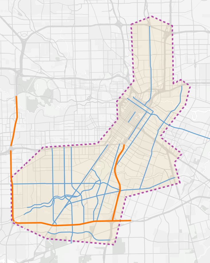
Map: Ken Ellis/Houston ChronicleSource: Houston-Galveston Area Council
Transportation research shows that major sporting events can increase traffic from 20% to 40% in nearby areas, according to the Houston-Galveston Area Council.
The Texas Department of Transportation warned that both highways and city streets are expected to carry significantly more traffic than normal during the tournament and encouraged visitors to use public transit or rideshare services when possible.
Which days will have the worst traffic?
The days that will likely generate more traffic fall on June 11-14, June 17, June 19-20, June 23-26, July 4, July 7-12, July 14-15 and July 18, according to the Commute Game Plan website, which was launched by transportation officials to help commuters deal with traffic during the World Cup.
Regional planners have mapped out the calendar, tracking not only World Cup match days, but also FIFA Fan Festival activities, Astros games, downtown conferences and Fourth of July celebrations.
SEE WHICH AREA AFFECTS YOU THE MOST: Which Houston freeways have the worst traffic jams?
Many matches are scheduled for noon on weekdays, which means fans may arrive during the morning commute and leave before the peak rush hour.
Will TxDOT continue major construction projects during the World Cup?
Houston is infamous for its lengthy highway construction projects. However, commuters will see the massive Interstate 45 rebuild scaled back to keep people moving during the World Cup.
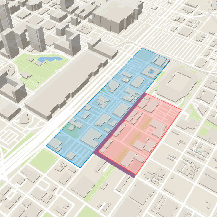
For those traveling through major corridors, the Texas Department of Transportation is pausing parts of the project in East Downtown from June 1 through Aug. 1. St. Emanuel Street between Commerce and McGowen streets is planned to open. Construction on Chartres Street between Commerce and Runnels streets will pause for the World Cup.
TxDOT pauses road work for the 2026 FIFA World Cup
There will be no construction along St. Emanuel Street and its cross streets in East Downtown, according to the Texas Department of Transportation. The portion of St. Emanuel Street between Jefferson Street and St. Joseph Parkway will open on June 7. Work on Chartres Street between Commerce and Runnels streets will also pause. However, construction is set to continue in some areas, including the detention pond near the Buffalo Bayou, the Alabama Street bridge over Interstate 69 and Hamilton Street between St. Joseph Parkway and Gray Street.
This frees up a stretch for people to use while traveling between downtown and East Downtown.
Crews are trying to avoid closing Interstate 69 during the Alabama Street bridge work. The stretch of I-69 between Texas 288 and Interstate 10 is the second-most-congested highway in Texas, according to data from the Texas A&M Transportation Institute.
Construction will continue on Alabama Street, Hamilton Street between St. Joseph Parkway and Gray Street, and a detention pond, designed to temporarily hold stormwater runoff and release it more slowly, between Runnels Street and Buffalo Bayou. Work on the pump station at Chartres and Jefferson streets will also continue.
Pedestrians and cyclists traveling through East Downtown may notice temporary improvements designed to make the area easier to navigate. Crews will install sidewalks, ADA-accessible ramps, and other walkable connections in the construction zone.
TxDOT officials acknowledged that construction can be inconvenient and difficult for travelers, said Michael Zientek, a liaison with a Houston-based public relations firm partnering with TxDOT. Crews will try to minimize construction disruption by working with the city of Houston and its partners, including the East Downtown Management District.
Will traffic on toll roads get worse?
Commuters who take toll routes will need to be aware of a potential increase in traffic on the Hardy Toll Road, due to its connection to George Bush Intercontinental Airport, and on the Westpark Tollway near West Loop 610.
“The worst traffic will probably occur in the hours leading up to game time,” said Tracy Jackson, spokesperson for the Harris County Toll Road Authority, in an email. “If it does, it will likely be at the point where our system connects to the other regional freeways.”
Visitors can purchase EZ tags online or at local EZ tag stores to receive discounted toll rates, while drivers without tags can pay tolls online using their license plate information or through rental car agreements.
What streets will close near FIFA Fan Fest?
Fans attending the East Downtown Fan Festival, located south of Shell Energy Stadium, can expect temporary road closures near Hutchins Street, Polk Street, Walker Street and Emancipation Avenue. The closure will remain in effect through Aug. 7.
These closures around the Fan Fest site will be on a rolling basis, with some streets closed for the duration of the event and others temporarily closed during Fan Fest operating hours.
The parking lot in front of Shell Energy Stadium will be affected by the closure. Drivers should expect changing traffic patterns and detours in that area.
World Cup street closures near Shell Energy Stadium
To prioritize safe pedestrian movement and reduce traffic congestion leading up to and during the FIFA Fan Festival Houston, temporary road closures will be implemented around the East Downtown event area on a rolling basis between May 1 and August 7, 2026. Closures will primarily impact streets near the festival site, including Hutchins Street and Polk Street.
Despite the planned street closures, drivers can still use roughly 93,000 parking spaces within three miles of the Fan Fest site, host committee officials said in April.
The host committee said people can still travel around the area by using nearby Metro rail lines, designated rideshare pickup and dropoff spots, and walking routes between downtown Houston and East Downtown.
What public transit options are available?
Transportation officials hope more people get out of their cars and consider alternative transportation options during the World Cup. Anyone planning to ride public transit in Houston can anticipate boosted service and extended hours across its rail and bus networks. Key days will have 24-hour rail operations.
The Red Line, which has the Stadium Park/Astrodome rail station for anyone trying to get to NRG Stadium, will arrive every six minutes during peak periods with two-car trains to maximize capacity.
Local bus service will have more frequent trips and longer hours on major routes. These enhanced routes include 2 Bellaire, 20 Canal/Memorial, 25 Richmond, 26 Long Point/Cavalcade Shepherd, 41 Kirby/Polk, 82 Westheimer, 85 Antoine/Washington, 108 Veterans Memorial Express and 151 Westpark Express.
Park & Ride options will also offer frequent connections between the suburbs and downtown. The service will operate certain routes seven days a week with extended hours, increased frequency and off-peak service running every 30 minutes until midnight.
HOW BAD WILL TRAFFIC GET?: Will Houston drivers give up their cars during the World Cup?
Visitors arriving from Bush Airport and William P. Hobby Airport can take the 500 Downtown Direct bus route from 5:30 a.m. to 8 p.m. The bus will operate every 30 minutes daily.
Additional buses and trains will be staged at key locations to respond quickly to surges. People will have access to directions, multilingual signage and real-time travel information. Metro also has an interactive map so people can see the routes of all of its public transit.
Unlike other cities that hiked their fares, Metro will keep its current bus and light rail fares at $1.25. Regular Park-and-Ride options range between $2 and $4.50.
Riders can pay fares with contactless credit or debit cards, Apple Pay, Google Pay and the reloadable RideMetro cards.
Physical RideMetro cards are $2 at Metro RideStore locations, ticket vending machines at rail stations, participating retail stores or online. Riders can also download the RideMetro mobile app and create a free virtual fare card.
How are rideshare services preparing for the World Cup?
Lyft plans to provide riders with detailed information about the venue layouts, pickup and drop-off logistics.
Lyft will offer promo codes and hopes to introduce European Freenow users to the service for the first time while they visit Houston for the tournament, said Lily Zahn, a Lyft spokesperson.
Waymo offers self-driving vehicles available in the city. Riders can request cars in Houston Heights, Montrose, Upper Kirby, Midtown, Woodland Heights, Rice Military, First Ward, Fourth Ward and downtown Houston.
The company expanded its service into more Houston neighborhoods, such as East Downtown, the Texas Medical Center and northeast Houston, ahead of the World Cup. NRG Stadium is included in the expansion.
Waymo spokesperson Chris Bonelli said riders will be able to view pickup locations, estimated wait times and pricing in the app before requesting rides, while also offering scheduled rides up to one hour in advance during periods of high demand.
What are the pedestrian-friendly spaces in Houston?
Residents and visitors will get a chance to test out the major pedestrian-focused downtown redesigns ahead of the World Cup to help fans move between downtown, East Downtown and transit hubs.
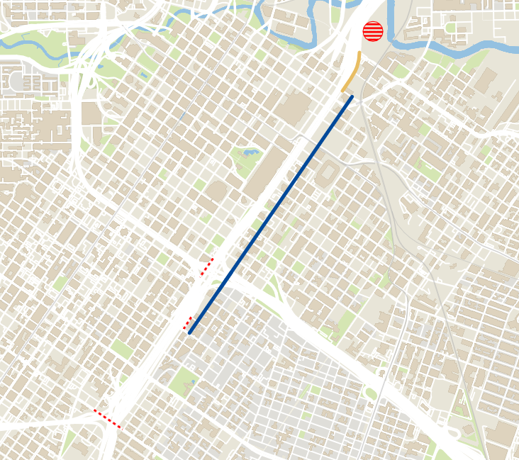
The new Main Street Promenade is a redesign of seven blocks of Main Street in downtown Houston that will convert the corridor into a pedestrian-focused public space. There will be wider walking areas, a public gathering space and blue tile-inspired street murals.
The Main Street Promenade will run from Commerce Street to Rusk Street. It’s scheduled to open May 30.
Pedestrian paths for the 2026 FIFA World Cup
The broader pedestrian-oriented route network called “Via Fútbol” will serve as a guide for fans heading to the FIFA Fan Festival and other destinations. Oasis zones for people to take a break, cool off, get food or drinks and enjoy the Houston scenery will be located around downtown Houston and East Downtown. These pedestrian path amenities are available to visitors and residents from June 11 to July 19.
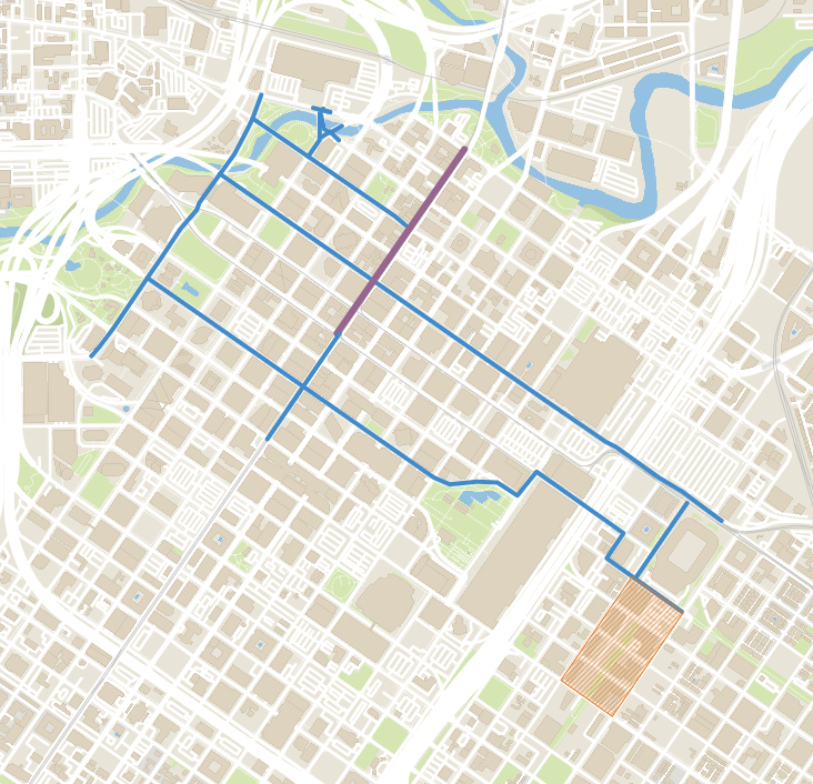
The broader pedestrian-oriented route network called “Via Fútbol” will guide fans between downtown transit stations, the Fan Fest site and surrounding entertainment districts, helping visitors navigate between bars, restaurants and other destinations.
When walking through the pedestrian pathways, including on Bagby Street, Preston Street, McKinney Street, Texas Avenue and Rusk Street, people can follow the colorful walking paths and signs directing them to the World Cup-related events.
For drivers, those streets are still open. The pedestrian pathways will be enhanced with directional signage, wayfinding and links to “oasis zones.”
These oasis zones are places for people to access bathrooms, shade, cooling areas, water, food, seating and visitor information. The oasis zones consist of the Houston Public Library, Main Street Promenade, Discovery Green, Trebly Park, Market Square Park and 1515 Texas Avenue.
The Houston Public Library will open from Monday to Thursday from 9 a.m. to 6 p.m., Friday from 9 a.m. to 5 p.m. and Saturday from 10 a.m. to 6 p.m. Discovery Green will open daily from 9 a.m. to 11 p.m. Main Street Promenade, Trebly Park, Market Square and 1515 Texas Avenue will open daily from 9 a.m. to 10 p.m.
Bicycle riders can also travel on shared-use paths and bike lanes. The Green Corridor, a 14-mile sustainable transit and trail network, connects MetroRail, Brays Bayou Greenway and the Columbia Tap Trail.
What happens if there’s a crash or traffic jam?
Houston TranStar will serve as a regional command center during the World Cup as it works with law enforcement, emergency medical services and fire departments and transit partners.
Officials are adjusting the timing of traffic signals along key routes to reduce delays for residents and visitors traveling between event sites, said Myers, spokesperson for Houston TranStar.
Drivers can also expect to see a larger law enforcement and emergency response presence across Houston highways during the World Cup, Myers said. Officials are beefing up resources throughout the region in case vehicles crash, stall or encounter roadway hazards.
If there’s an incident on the road, drivers can check the Houston TranStar map for updates. If they need their car to be towed, they can contact the Tow and Go service at 713-881-3333.
“We all know that this is going to be a major global event taking place in the greater Houston area, and that’s going to bring more congestion on our roadways and highways,” Myers said.
Staff writer Peter Warren contributed to this report
